Jacksonville FL History
Part 2
15336.43 Robert
7
BIGELOW, was the son of Benjamin
6
( Paul 5 ,
Cornelius
4,
Samuel
3,
Samuel
2,
John
1) and
Eunice (AIKEN) BIGELOW, was born 17 October 1797 at Norfolk, Litchfield,
CT.
There is an interesting oral history about Jacksonville that mentions
the Bigelow Plantation:
There is more history of Jacksonville including cemeteries and houses
including Robert Bigelow at jackvil3.htm
This passage below and email from Ann White lead me on this research......ROD
"One enjoyable feature was the moonlight boat-rides on the St. Johns.
There were no railroads running up the river, so these boat excursions
terminated at Green Cove Springs, Middleburg, and Arlington. Those were
also favorite picnic spots. "In horseback riding, we used to go out some
distance on the old plank road towards Lake City, and again on the 10-mile
drive around by Talleyrand Avenue along the River and back.
"The Springfield section from the time of my early boyhood was known
as the Jones Plantation. Mr Jones was the grandfather of the late Mr. William
Bostwick.
"At Arlington was the Sammis Plantation. Mr. Sammis' wife was an
African Princess.
"On the South side of the River were the [Hudnall?] Plantation,
Phillips' Plantation - Red Banks - the Hendricks', Hegarths', and the Bigelow's
at Strawberry Creek. (Rod's Note: Strawberry Creek was near the present
day intersection of Arlington Expressway and Arlington Road. [207 Noble
Circle West. John H. Sammis house, circa 1855] [1300 Oak Haven Road- Francis
Richard I and II residence, circa 1848][ Orange Avenue and Grove Street
border the Samis property later owned by William Matthews " Arlington Bluff
Assoc."][ Bacon place is Bigelow Place, and was the site of a movie location.
smoke pouring out caused alarm until it was discovered that a movie was
being filmed])
I talked to a number of residents in
the area in the spring of 2000 and did some research at the library. I
did explore Floral Bluff and found what I believe is the foundation of
the old Bigelow Plantation. It is on a Bluff along the river and near where
Strawberry Creek once was. It is also only a couple blocks from the Bigelow
cemetery. Below is a map and more information about the Plantations........................ROD
09/02/2000.
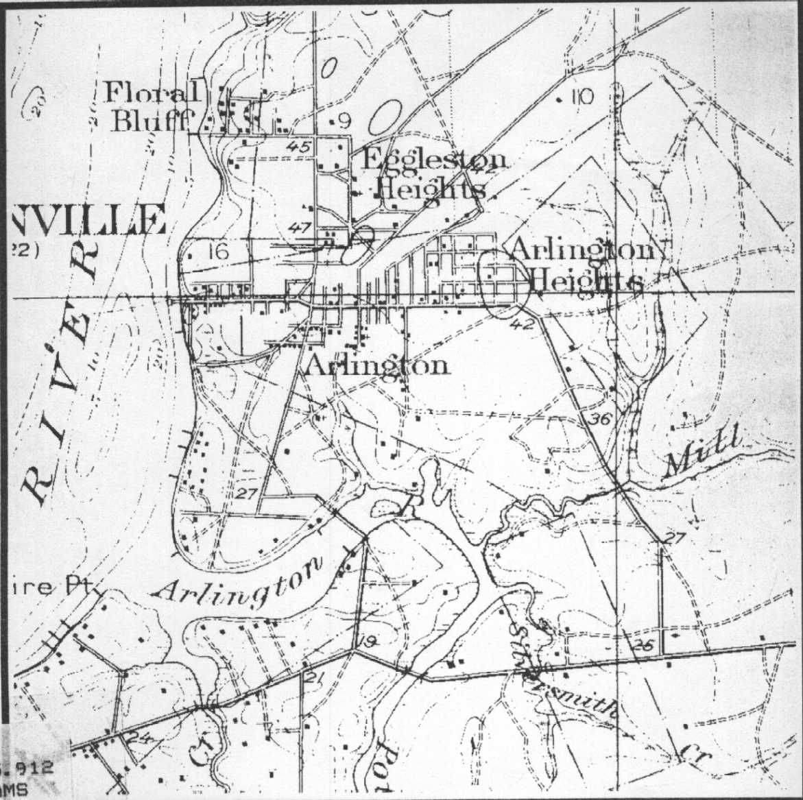
This map shows the Arlington area of
Jacksonville along the St. John's River. The cemetery is in the Floral
Bluff area.
A History of Arlington
Arlington occupies the comer of land
shaped by the abrupt eastward turn which the St. Johns River makes before
it empties into the Atlantic Ocean some seven miles distant. The Arlington
River, hardly a mile in length and flowing out of Pottsburg Creek, historically
formed the neighborhood's southern boundary. By recent definition, Atlantic
Boulevard, an east-west running thoroughfare less than one-half mile south
of the Arlington River, constitutes the southern edge of
what is commonly called Arlington. The neighborhood's east boundary
is more difficult to define, shifting with the city's outward crawl. Before
the growth that followed completion of the Mathews Bridge in 1953, the
population of Arlington was essentially gathered between the St. Johns
River and what is now Rogero Road.
Arlington Expressway, which runs
parallel to Atlantic Boulevard on the north side of the Arlington River,
provides the other major east-west thoroughfare in that part of the city.
University Boulevard constitutes the main north-south artery of highway
travel, running parallel to the St. Johns River. Commercial establishmeuts
line Atlantic Boulevard, the Expressway, University Boulevard, and Arlington
Road. Arlington elsewhere generally consists of residential neighborhoods
set within heavily wooded areas. The land along the river in the north
part of Arlington rises to high bluffs, uncommon to northeast Florida and
offering well situated and picturesque residential locations.
Throughout prehistoric and early historic
period times, Indians, Spanish explorers, and British colonists in turn
made their way through what is now Jacksonville, which provided the most
convenient place in northeast Florida to cross the St. Johns River. Referred
to as Cow Ford during the Second Period of Spanish Occupation (1785-1821),
the area experienced little development before the United States acquired
Florida from Spain in 1821.
Isaiah D. Hart, who emigrated from the St.
Mary's River area, surveyed and laid out the town of Jacksonville in 1822.
The city became a major shipping port during the century and eventually
a center for the insurance industry. Rail and steamship service to northern
markets transformed the city at the end of the nineteenth century into
the gateway to the Florida peninsula. As a result, Jacksonville's population
rose steadily, its growth fueled by the steady annexation of surrounding
suburbs. Arlington, on the east bank of the river, did not truly join the
city until 1953, when construction of the Mathews Bridge provided the first
direct link between downtown Jacksonville and lands on the east bank. Consolidation
of Duval County in 1969 officially brought Arlington within the city's
fold. Extension of Merrill Road eastward in the mid-1960s and opening of
the Regency Square Mall in 1967 inaugurated a period of intensive growth
that continues as the century nears its end.
Prehistory
Archaeological evidence suggests that the first
human occupation of northeast Florida occurred during the Middle Archaic
Period (5,000 - 2,000 B.C.). The original inhabitants consisted of nomadic
tribes from the North Central Highlands region, who migrated to the St.
Johns River basin on yearly hunting and gathering expeditions. Not until
the Middle Prehistoric Period (1,000 B.C. - 1,000 A.D.), however, did year-round
settlements in northeast Florida appear. The Indians, who set up permanent
village sites, depended on the abundant fish and game found in and along
the St. Johns River for their subsistence. Sites excavated in Duval County
dating from the Middle Prehistoric Period tell a story of an advanced culture.
The Indians conducted elaborate burial ceremonies, made their own pottery,
and traded with neighboring Indian tribes. The cultural lifeways established
by those early aboriginal groups changed little until the seventeenth century,
when Europeans and Indian tribes from the north displaced the indigenous
people.
Evidence of the prehistoric inhabitants in
this section abounded until recent decades. The most conspicuous prehistoric
feature remaining in the early twentieth century was the so-called Shields
Mound, a hill so large that it appeared from the river to have been a bluff.
Located in the Gilmore settlement, Township 2 South, Range 27 East, Section
1, the mound stood some 150 yards from the river bank. One observer in
1936 described it as "slightly oblong, with rounded corners." The mound
had a diameter of about 214 feet at its base and a summit plateau of 115
by 133 feet. It rose some eighteen feet above the surrounding surface.
A frame residence surrounded by giant oak trees stood atop the mound in
the 1880s,
before C. B. Moore, an archaeologist employed by the federal government,
began conducting the first excavations there. The building later burned.
Moore discovered the remains of some 150 bodies,
suggesting that the mound served a burial as well as ceremonial function.
It probably provided the base for an elevated structure. Truncated pyramidal
mounds of that kind, archaeological relics of Florida's Mississippian Period
(c. 1100 A.D.), virtually lined the banks of rivers and streams throughout
the northern part of the Florida peninsula.
Early twentieth century road builders mined
many of them for their shell content to make road beds. Modern development
later removed all but a precious few. The Shields Mound disappeared shortly
after World War Two, probably when construction of the Mathews Bridge spurred
the initial burst of post-war development.
continued on jackvil3.htm ...............
Modified - 01/19/2003
(c) Copyright 2003 Bigelow Society, Inc. All rights reserved.
Rod Bigelow - Director
< rodbigelow@netzero.net >
Rod Bigelow (Roger Jon12 BIGELOW)
P.O. Box 13 Chazy Lake
Dannemora, N.Y. 12929
 < rodbigelow@netzero.net
>
< rodbigelow@netzero.net
> 
BACK TO THE BIGELOW
SOCIETY PAGE

BACK TO BIGELOW
HOME PAGE